Part 1 - Mapping
Arthur Knight, brother in law of George Henry Brown (d 1916, name sake of the Brown in Bukit Brown Cemetery) once Assistant Colonial Secretary of Singapore) once wrote during the jubilee of 1887 and were found in MSS among his papers
Singapore founded Feb 6th 1819. Queen Victoria born May 24th 1819
The following were written at the Jubilee of 1887
Empress and Queen, thy star and ours
Are held aloft by kindred powers
for the same year that saw thy birth
Gave us a destiny on earth.
Thou shalt not lack our tribute praise,
Who reckon life by thine own days,
We who have prospered in thy smile
In this why far off Birthday Isle.
(Ref: Singapore Fress Press and Mercantile Advertiser , 14 Jan 1919)
The same page also contains a mention of the early history of Singapore from the landing of Sir Stamford Raffles in Singapore
1829 - What we now called Stamford Canal, had the appropriate (perhaps then) name of Freshwater Canal,. Inland the town apparently extended as far as the foot of Flagstaff Hill (Fort Canning). The New Harbour is designated the "Silat or Native Strait." Pulau Tambakul, or Goa Island, north east of St's John (of which Raffles ship had anchored ten years before, was the Signal Staff, marking the turn from the Straits into the Road (by Walter Makepeace who co-edit the One Hundred Years of Singapore commemorate Singapore’s centenary in 1919)
(NB: currently Kusu has a previous names of P Tambakul, Goa or Signal Island).
Question is, where is this St John Island that Sir Stamford Raffles's ship anchored ?
The answer is not so simple as it seem.
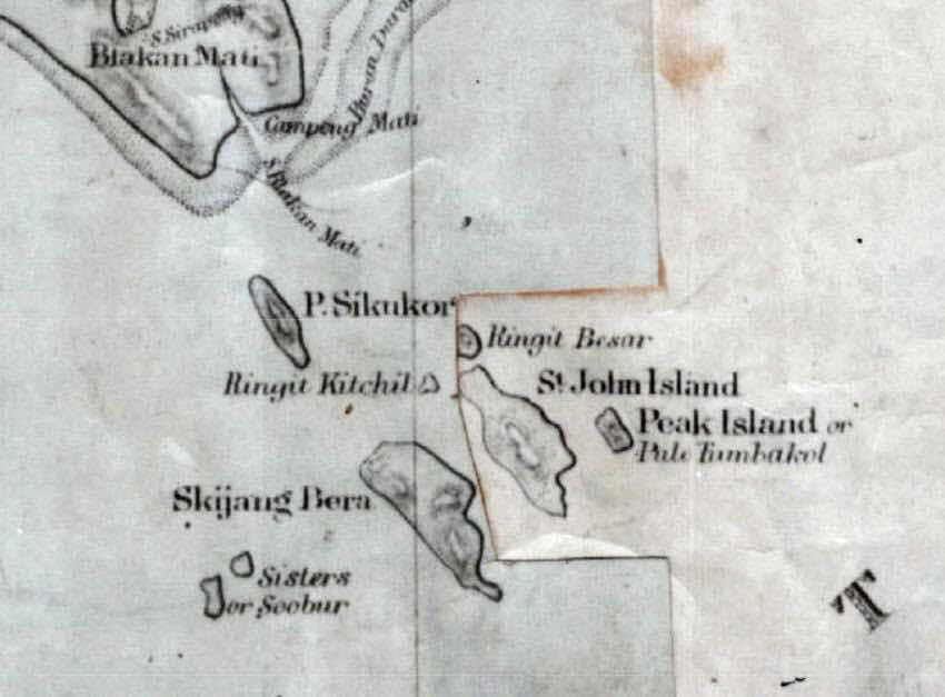
As early as 1805, Captain George Thomas (NAS map) has assigned some of the Southern Islands the following names following the apostles of Jesus:

Here, Pulau Tekukor was labelled as Luke, current St John and Lazarus Island lumped as just St John Island
and Sister Islands as Mark and Matthew
In 1819, Captain Ross , the hydrographer of the East India Company who accompanied Raffles and William Farquhar to Singapore, prepared the map while Raffles was negotiating with the Temenggong to establish a trading post, drew the first full historical map which shows the harbour and adjacent coast of the Singapore Island, including a few offshore islands, such as the St. John's Island, at the time of Stamford Raffles' first landing on Singapore.

Although, there are two ST John Islands at that time, he cleared labelled Lazarus Island as St John Island with an hill (189 ft, see below 'China Sea Directory") and another peak at Pulau Tembakul (100 ft)
Another more interesting map surveyed by Farquhar (NAS) described as
"The settlement environs, New Harbour, and adjacent islands surveyed by Lieutenant Colonel Farquhar; the circuit of the island old straits and islands by Captain Franklin, assisted by J.F Bernard Esquire; sounding from the Charts of Captain Ross and Mr. Horsburgh. From Colonial Office and Predecessors. Maps and Plans. Series 3"
"
shows clearly the Signal Flagstaff at Pulau Tambakul (Goa or current Kusu Island), and the two islands as St John Island or Po Sijong.
The Signal flagstaff was used as a device to communicate the movement of ships passing through Singapore at that time.
Later on a flagstaff was established at Fort Canning, and used to
display the arrival, identity, location and status of ships entering
Singapore Harbour.
In a later 1845 map updated by Turnball Thomson based on Captain Ross earlier map shows current Lazarus Island labelled just as St John Island and current St John Island labelled as Sikajang Island!
(NAS : The hydrographic chart is Admiralty Chart No 1341, surveyed by Capt Daniel Ross in 1827 and Turnbull Thomson in 1842, with additions to 1845)

So too in a 1863 map (Map of Island of Singapore and Its Dependencies by Major General Sir Harry St George Ord, governor of
the Straits Settlements)
Here current St John Island was known as Skijang Bera and current Lazarus Island was known as St John Island
1886 description
"The China Sea Directory contains the directions for the approach to
Singapore, published in London in 1886 described the islands as follows:
The Sisters are two small islets not quite a mile to the westward of
West St. John island; the South Sister, named Pulo Subur, is 89 feet
high.
They are surrounded by reefs to the distance of a cable, and close to
their edges are irregular soundings of 5 to 9 fathoms. Southward of the
South
Sister the soundings soon deepen. The channel between them and West St.
John is free from danger, with depths of 14 to 24 fathoms. Nearly half a mile W.S.W. of the Sisters is a bank of 3 fathoms, with 5 and 6
fathoms between, and a short distance westward of this bank is another
of 5 fathoms.
St. John islands, three in number, form the south-western limit of
Singapore road. They lie about north-east and south-west from each other, extending nearly a mile in those directions. West St. John island is about one mile long north-west and south-east and a quarter of a mile broad. Its south-east extreme is joined to the
main body by a narrow neck of low land, which at a little distance gives
it the appearance of a separate islet.
A reef extends about a third of a cable from its southern and western sides, and 1 cables from its eastern side.
The middle island, known as East St. John island, is about half a mile
long north-west and south-east, a quarter of a mile broad, 189 feet
high,
and surrounded by a reef which extends a little over half a cable from
its south point, and 1 cables from its south-eastern shore.
Peak island, or Pulo Tambakúl, the north-ensternmost and smallest of
the three, has a peaked hill 100 feet high. The island is encompassed by
a reef which extends about three-quarters of a cable in a southerly and
south-easterly, and 2 cables in a north-westerly direction.
A white stone obelisk on the sonth-east side of Peak island, marks the southern limit of Singapore road.
Between these islands are narrow channels about half a cable wide, with depths of 6 to 16 fathoms.
In the space hetween St. John islands and Blakan Mati, are a few small
islands and several extensive reefs. Between the latter are channels of
deep water, but they are so narrow and intricate as to be useless for the purposes of ordinary navigation
Pulo Ringat is the easternmost of two small islets which lie close to the north-eastward of St. John islands.
1906 map by J W Reed showing East and West St John Island. St John
Island has other names of Pulo Sakijang or Lazarus or Convalescent
Island)
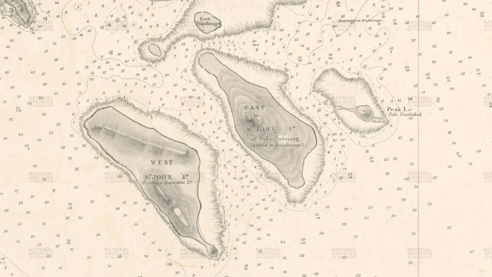
The last time East St John Island appeared on the map could be as late as 1987

Here you can see the height of the peak at the island : St John Island (P. Sakijang Bendera) 28 m = 91.8 ft, St John East (P. Sakijang Pelepah, Lazarus Island) 56 m (183.7 ft)
and Kusu Island 30 m = 98.4 ft
Part II - History
The Quarantine Islands 1875
The Straits Times 14 August 1875 pg 4
1. There shal be set apart and appropriated for the Settlement of
Singapore two permanent Quarantine Stations, one of which shall be St
John No 1, and the other
St John No 2
If the vessel contains Passengers or immigrants, she shall proceed
immediately to the quarantine anchorage and such of her passengers and
crew as are ill of the disease with which she
is supposed to be infected, shall be landed at the Lazaretto St John No
2, and all her Immigrants shall then be landed and placed in the
Quarantine Station St John No 1
After such landing, the vessel shall perform quarantine at anchor for
the same time as shall be fixed for the quarantine of the Passengers,
Immigrants, or Crew landed from her at the Quarantine
Station
Straits Observer (Singapore), 25th March 1875
At the entrance to the harbour, there are three islands forming part
of the group of St John viz, Peak Island, St John No 1 and 2.
They are almost in an oblique direction to each other, the Eastern most
being Peak Island, the next St John 1 (ie Lazarus Island) and last of
all No 2.
The distance between Peak Island is not great, but between No 1 and 2
there is a pretty wide channel, which at high tides is not only a good
distance, but the strong currents
that prevail render it difficult to pass across.
The Lazaretto is placed on St John Island No 2, and consists of a European and Native Ward, with outhouses and etc and residences for the medical subordinate in charge.
On St John No 1 is erected a shed for the reception of such passengers as may be landed from an infected ship. And on Peak Island is the cemetery for such patients who may die at St John No 2.
On both St John No 1 and 2, the landing place is on the Eastern aspect of each island, and consequently the men located on each are not within sight of each other.
(see Cheang Hong Lim petition below which was approved in Aug 1875 that no more such burials be allowed in Peak island).
On 9th March 1875, Cheang Hong Lim, a Chinese leading merchant petitioned to the Colonial Engineer and Surveyor General
that Peak Island (Kusu Island) has been used as a holy place for people to pray to Twa Pek Kong Koosoo and Datok Kramat but that place has recently been desecrated by the internment of a number of dead bodies. His request was finally approved in Aug 1875 that no more burials was to take place in Peak Island.
(I believe then the burials switch to St John Island 1 ie Lazarus Island, see below)
The naming of Lazarus Island (1899)
On 25th March 1899, a report on the Straits Times Singapore Gazette published as follows (Straits Times, 25 March 1899)
the two islands known as St John Islands Singapore, has been renamed as follows :
The Western One " St John's or Quarantine Island", the Eastern Island "Lazarus or Convalescent Island".
The Beri Beri Hospital at the latter has been declared to be a prison under Ordinance XIV of 1872
So from 1899 onwards, the Beri Beri Hospital becomes a prison.
Fire on Lazarus Island
Straits Times 15 Sep 1902 Pg 5
Fire broke out on Lazarus Island (East St John Island) a short distance from the Quarantine Island.
A number of disused sheds were burnt down. These sheds were used some years ago as convict prison sheds, but given up shortly
after a life prisoner bolted and escaped, and they have not been used
since. It was thought that the fire was caused by some careless
fisherman
on the island who lit fires for cooking purposes
We can see therefore these prison sheds existing only for a couple of years but were burnt during the Sep fire of 1902.
Landing of French ship Cachar
8 Oct 1902 Pg 231
French Trooper Cachar landed 1,100 French troops at 3 am on Sep 25 on
island adjacent to Singapore. Spent 2 days in consolidating their
position. Subsequently landed on Lazarus Island
and took possession." With appropriate headlines the sensation would be
complete. Meanwhile many of the poor "Cachar" men are sick in the
General Hospital, and the rest are cursing
"Perfide Albion" for putting Batu Berhenti S'kejap in the fair way of the transports of France.
Based on the fact that Lazarus Island as Quarantine Station St John No 1, which contains a reception shed and receive quarantine passengers, and the fact that 1,100 troops can land on this island,
Raffles first visit to Singapore in Jan 1819
I will not be surprised of the two St John Islands, Raffles would
have anchored at St John Island No 1, which was closest to Signal Island
(Peak Island) and from thence, landed in Singapore on Jan 29, 1819.
Also from the 1819 map by Captain Ross, he has marked correctly the 3 peaks (Mt Serapong in Sentosa, peak in Lazarus island and peak in Signal Island). The fact that he only draw half the body of the current St John Island with no peak identified would mean to me Raffles vessel did not pass through Cooper's Channel, but instead anchored at the east coast of Lazarus Island, hence he draw the peak there.
Graves of people who succumbed to various infectious diseases
Lazarus Island Blaze
Singapore Free Press and Mercantile Advertiser, 4 June 1914, Page 7
There was a big blaze on Lazarus Island, near St John Island, on
Tuesday night owing to the jungle growth being set on fire by some
unknown means. The fire continued for several hours, reaching
such dimensions that it could be seen for several miles around and
almost all the vegetation in the island was consumed. There are several
graves on the island where persons who have succumbed to various
infectious diseases are buried and these, of course, suffered
considerably.
Erection of Aga Light House and light keeper Hut
July 1922 and Oct 1922
Singapore Free Press and Mercantile Advertiser
Government Notifications
Tender for the Erection of Complete Aga Light and Hut for the Light Keeping at Lazarus Island
As reported on the same newspapers on 15 Jan 1923 pg 10
The Light at East St John Island
The new flashing white light, which has been erected on East St John
Island which will come into effect on or about February 5th has been
erected.
The light would be of considerable assistance to ships approaching from
East and West, and also valuable guide mark to vessels leaving the roads
at night, through waters in the neighbourhood of the island
which are far from free of shoals
The Straits Times on 15 Jan 1923 report
The flashing white light, visible about 12 miles will be exhibited from a
lattice work steel structure which has been erected at the highest
point of East St John Island . The height of the structure is 21 ft 6 in
and the height of light above high water ordinary spring tides , 195
feet. The light will show one flash every 10 seconds viz, duration of
flash one second. duration of eclipse 9 secs. The light will be visible
all round the horizon except where obscured by neighbouring islands.
Lazarus - the forbidden ground that housed the dead from St John Island
The Singapore Free Press and Mercantile Advertiser 2nd Apr 1923
The St John Island Quarantine Station is one of the largest in the
world. At St John thre is accomodation for 6,000 people at the same
time.
This reference would not be complete without a brief allusion, fittingly
in conclusion, to the direct opposite in situation and in character to
St John - Lazarus Island
Lazarus Island is the forbidden ground to the public, it is here that
the dead from St John are buried, the sole companions of the solitary
watchman who tends the light at the summit of the island
Mention of Ammunition Dump
Fire on Pulo Lazarus
The Straits Times, 31 March 1930, Pg 12
The attention of a number of people in Singapore were drawn to a fire raging on the island of Pulo Lazarus yesterday afternoon.
It appeared to be of alarming proportions and fears were entertained for
the safety of 2 Malays who are the only inhabitants. There is also
believed to be an ammunition dump on the island,
but neither the Malays nor the ammunition were in danger. The fire which was due to burning Lalang lasted for 3 to 4 hours.
Cemetery of the Quarantine Station
St John Island
The Straits Times, 1st Jun 1935
About 200 yards farther along the shore there is another pier, but nobody is permitted to use it for landing, nor probably would wish to use it as it is the Mortuary Pier, so called because as its head there stands the little red roofed post mortem house. Here the bodies of persons who have died of contagious diseases are dissected and prepared for burial on Lazarus or East St john Island
A boat slung from davits close by, is employed specifically for the
purpose of conveying the dead across the narrowest portion of Cooper's
Channel to Lazarus Island, where no one but officials are allowed to
land. As the cemetery of the Station, it is forbidden ground to the
public and a solitary figure that tends to the light at the summit is
the only watchman over the graves grouped on the southern slope.
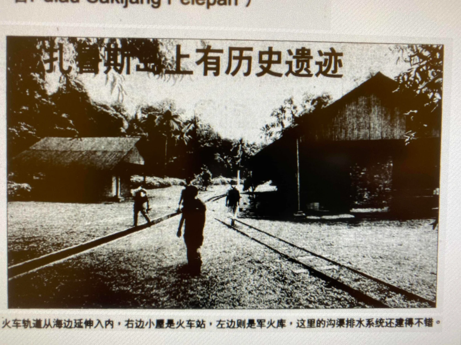
Zaobao Article 29 May 2001
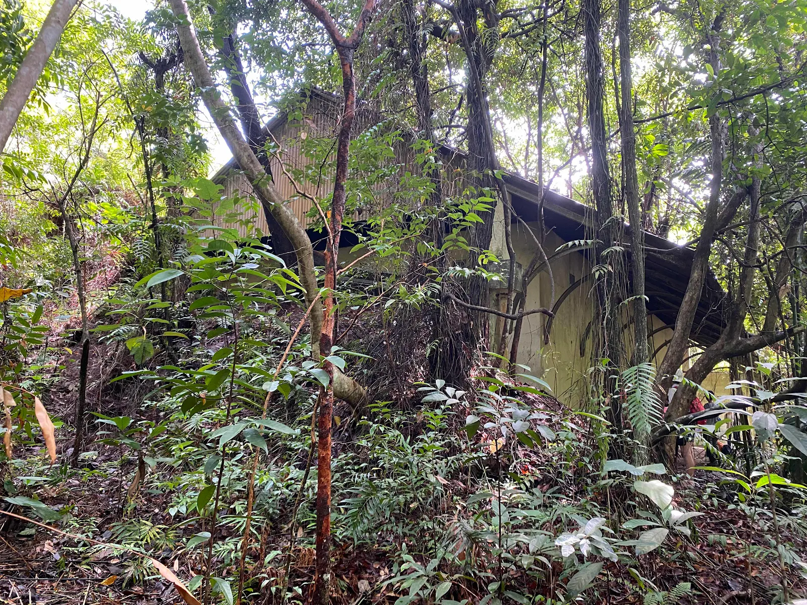
There are historic ruins at Lazarus Island
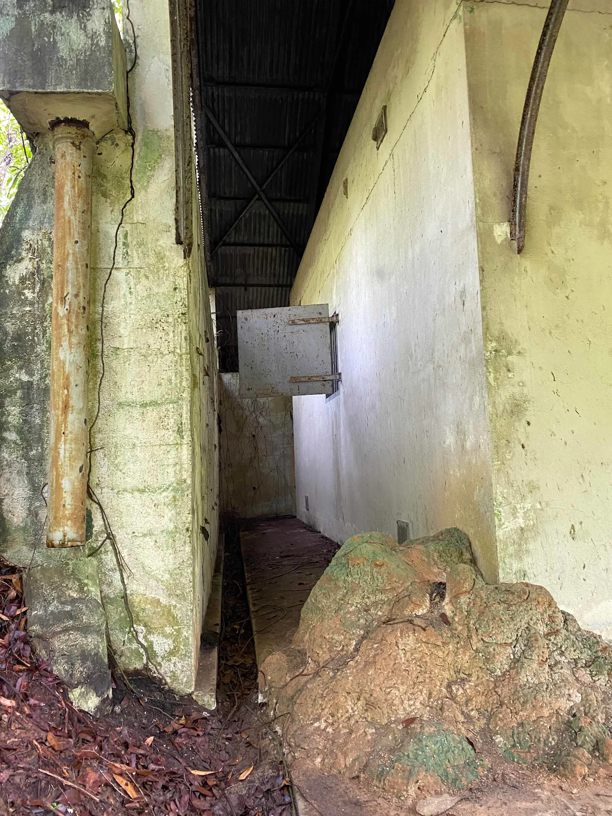
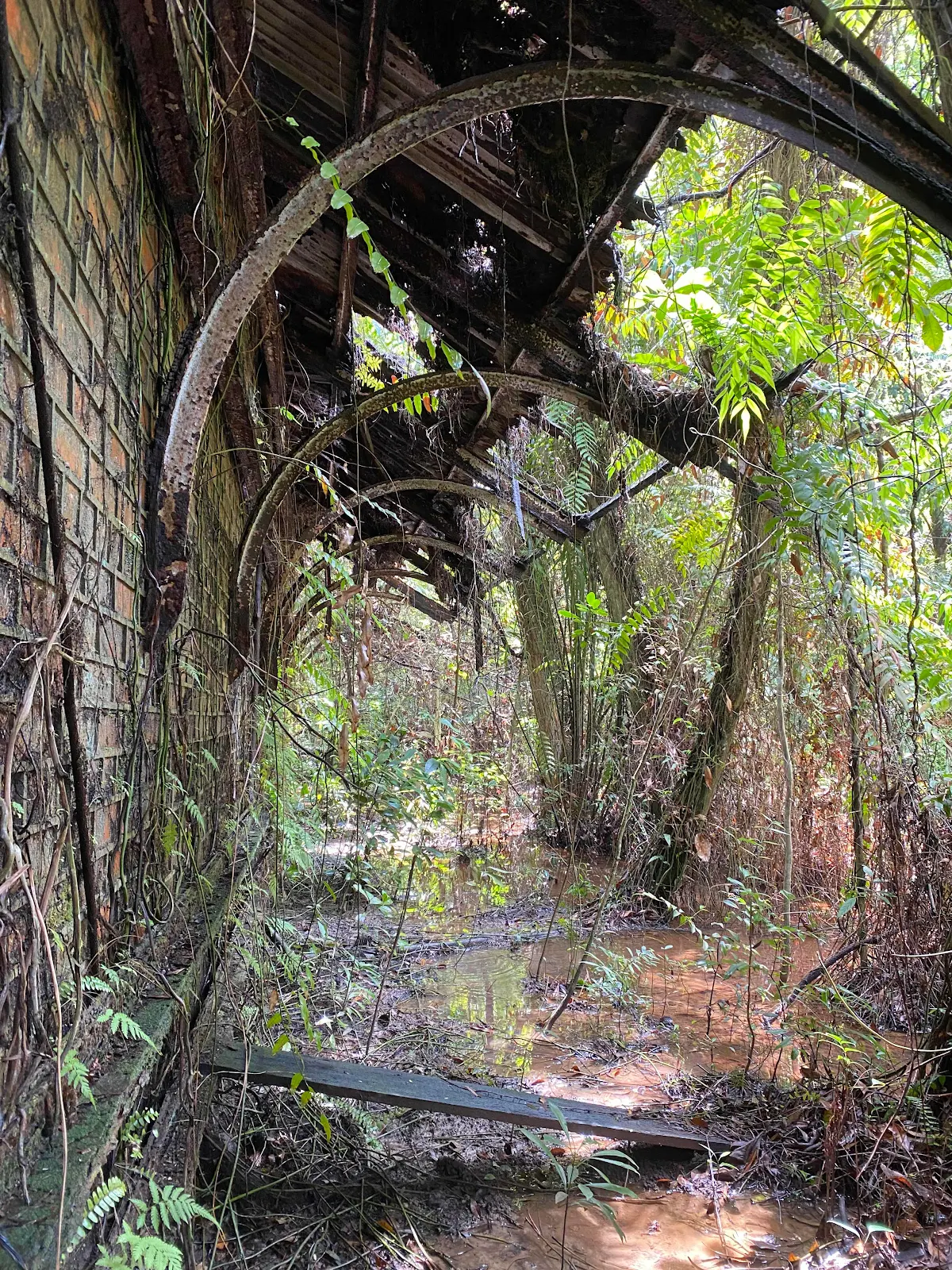
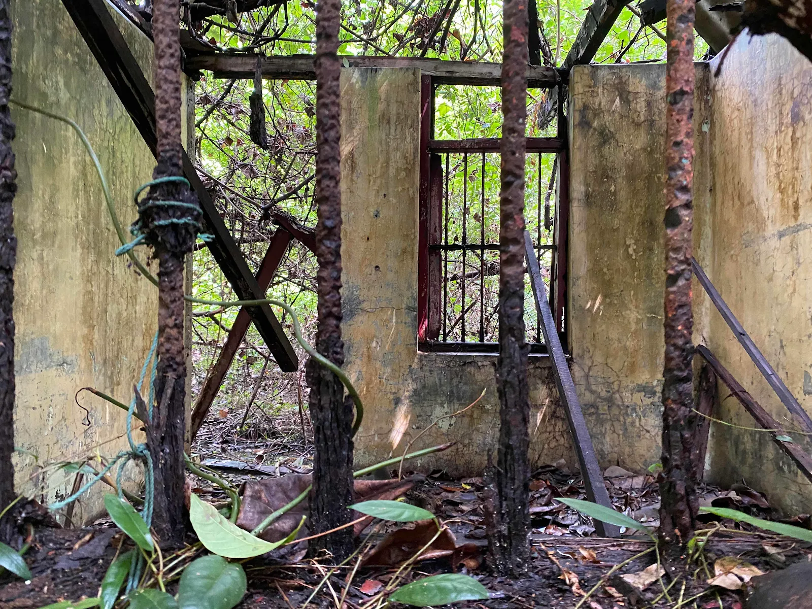
An assistant professor who was studying the biodiversity on Lazarus Island reported the discovery of a railway track that extend from the coastline to the interior, passing through an operations centre on the left, then through a railway post, opposite of which was an ammo dump. The track then go inside further to another ammo dump. The operations centre has 3 or 4 rooms. The railway post is typical, but the ammo dump has special construction. the 4 sided bricks structure is well preserved, thickly constructed and only iron door and one small window. The National Museum and Ministry of Defence did not have any records of these structures.
Right side - Railway post, Left side Ammo Dump. The drainage system is quite good
On the North East of the island facing the sea , can be seen the ruins of the foundation of structure with ten of dozens of standing lime columns. The rooms no longer exists, but there is square well, and washing point with waste water draining to the sea.
Beri Beri Hospital
(based on above description, this should be the ruins of the defunct beri-beri hospital.
At that time it was believed Beri Beri was a "place" disease and the treatment hospital was made close to the sea whereby the patients will bathe in the sea (Singapore Med J 1994; Vol 35:306-311). This hospital was then discontinued and repurposed as a prison from 1899 to 1902)
HOMING BEACON FOR EVERY STORE PLANE
The Straits Times, 8 April 1961, Page 15
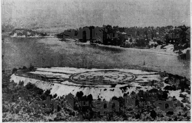

Lazarus Island, with the VOR (Very high frequency omni-directional range) equipment, seen in in the centre of the circle.
The Master Attendant's light is seen at the extreme left of the cleared area. St John Island, with its Civil Aviation non directional beacon masts is seen in the background.
The Heart Beat of Singapore's Civil Aviation navigational system which ensures the safety of all aircraft coming into the state, is tucked away on tiny Lazarus Island, close to St John Island
The two main types of radio navigational aids are Visual Omni Range (VOR) beacon and the Non-directional Beacons (NDB)
The more important of the two is the VOR. In early 1961, a new VOR Beacon was installed on the Lazarus Island near St John ISland
This Beacon operates in the very high frequency band of the aeronautical radio spectrum, transmitting in all directions.
From this beacon aircraft almost 200 miles out can pick up the signals and identify Singapore at once, this making it possible to pin point our airport.
In Sep 1993. the VOR Station at Pulau Sakijang Pelepah (Lazarus Island) becomes a protected place
May 2007 - ST Electronics commissioned the Distance Measuring Equipment (DME) System on Lazarus Island for the Civil Aviation Authority of Singapore. The DME system can interface with existing Instrument Landing System (ILS) and Very High Frequency Omnirange (VOR) system
2000 - Singapore Tourism Board started work to redevelop the Southern Islands, linking Seringat and Lazarus together to form a larger island and linked to St John island by a causeway. The reclamation and infrastructure project was completed in Dec 2006
(NAS map 2015)

Jan 1, 2022

Lazarus Island is now a popular relaxing recreational island with sandy with beach
Part III - Current ruins and tombs
Ammo Dump 1
Ammo Dump 2

Ammo Dump 3


(Likely) Operations Cell with Chimney
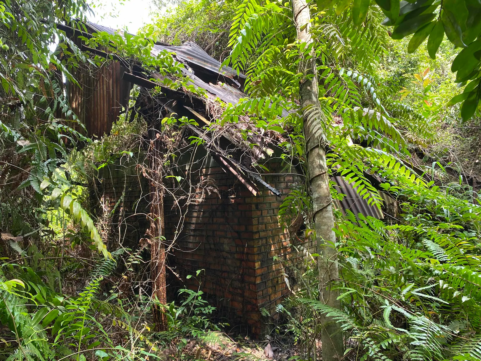
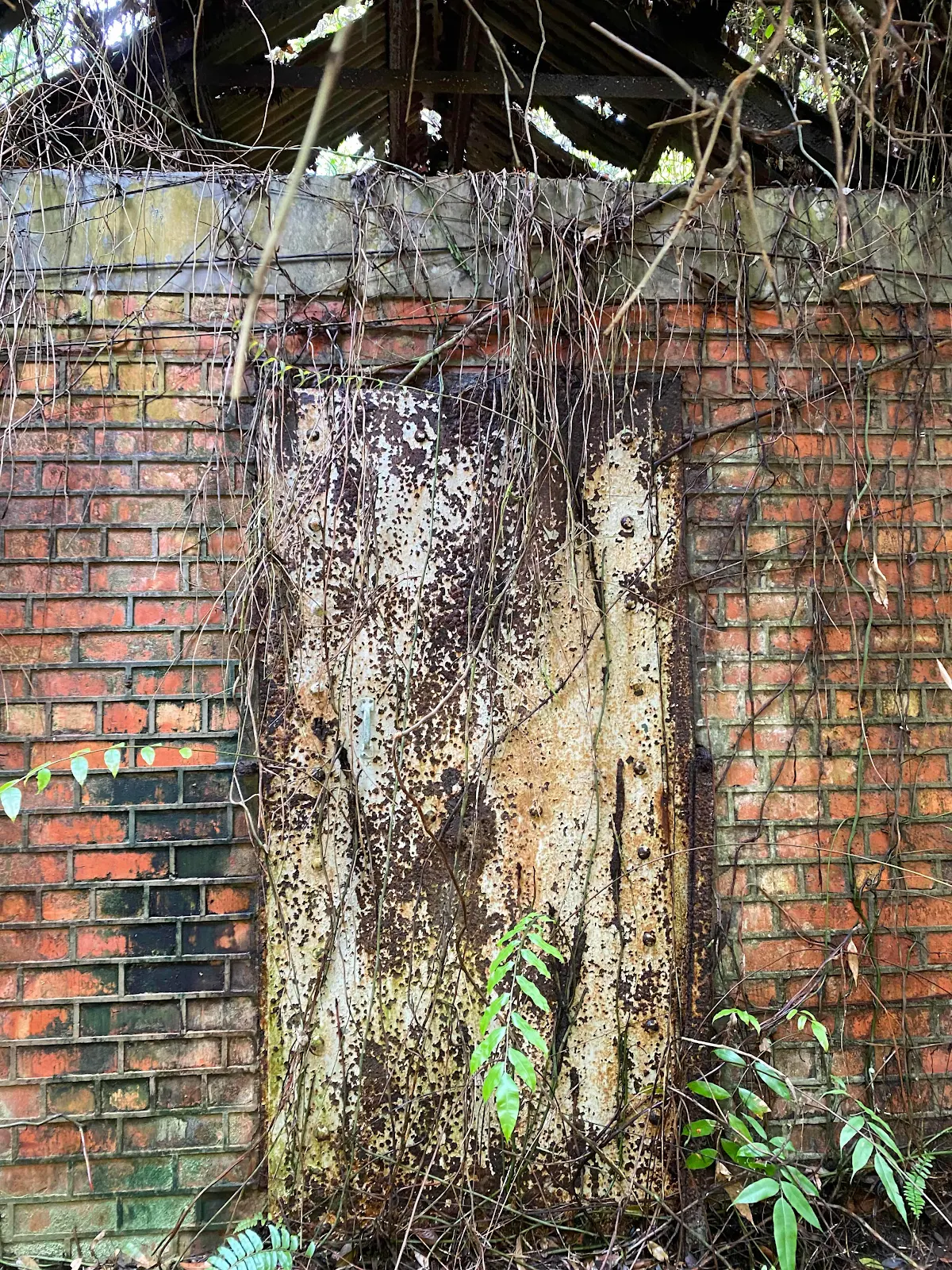
Note : the Bricks look like late 19th Century / Early 20th Century Structure


1896 map of Southern Islands
Note Fort Serapong and Siloso were fortified at around late 19th and early 20 century, so I believe the ammo dumps, the cell and the railway to be around the same period .

Tombstone of Seet Khian Khun, died 1928, 3rd moon
Filial Son : Hock Seng
Tombstone of Lo Kwee Huat, erected 7th month, 1938
Ancestry place : Penghu County of Taiwan
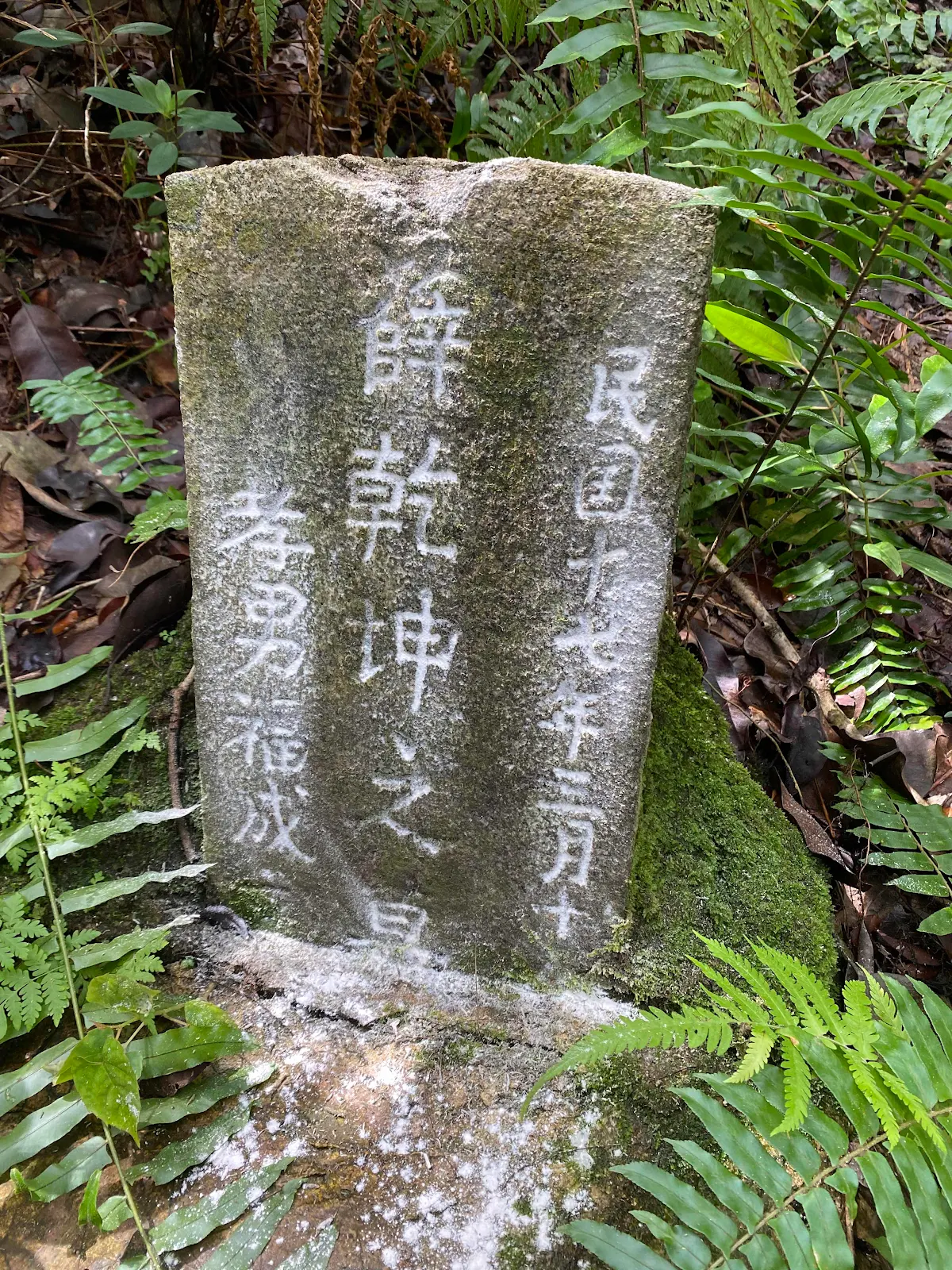
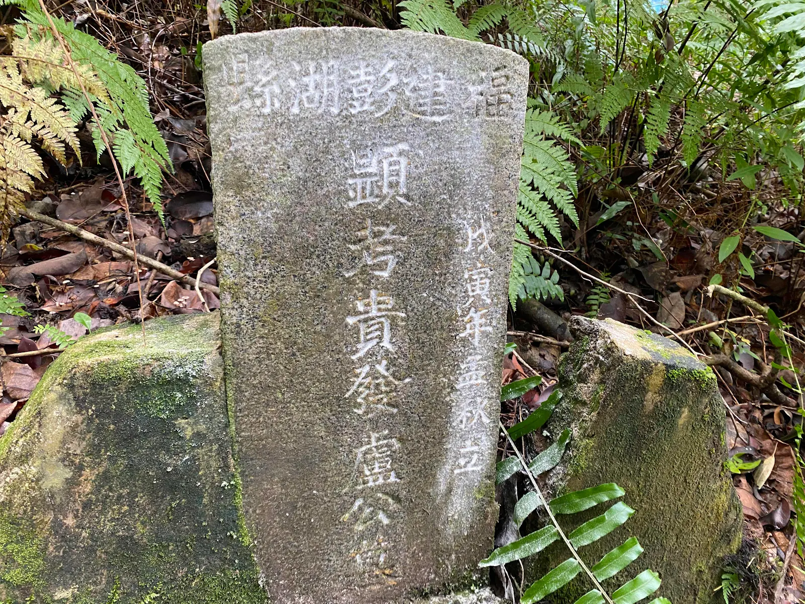
These two tombs are located near the operation cell on a higher slope.
Based on the simple tomb construction of the two tombs, they could be the deceased from the Quarantine Station in St John Island, whereby Lazarus Island was used as the cemetery during that period.
There might be more tombs to find, especially on the southern part of the island
There used to be a Muslim cemetery on the northern part of the island. It should be cleared due to the recent development.
We also need to find the railway tracks and other ruins as well
Research ongoing and blog will be updated with new findings
Compiled by Raymond Goh
Comments
Post a Comment